COLLECTION NAME:
Japanese Historical Maps
Record
Author:
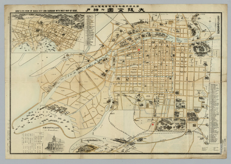
Shimizu Yoshiyasu
Date:
1902
Short Title:
Daigokai Naikoku Kangyō Hakurankai hikkei Ōsaka zenzu = Bird's eye view of Osaka City and Harbor with inset map of Kobe.
Publisher:
Osaka : Tamura Hōseidō
Type:
Separate Map
Obj Height cm:
49
Obj Width cm:
73
Scale 1:
Scale not given
Note:
Lithograph In Japanese and English. Shows points of interest pictorially. 1 inset: Kōbe-kō no zu. Includes sketch map of Exhibition grounds and buildings on verso. Includes index of key government buildings, businesses, bridges, schools, and factories. Title on map: Daigokai Naikoku Kangyō Hakurankai kanran hikkei Ōsaka zenzu fu Kōbe = Bird's eye view of Osaka City and Harbor with map of Kobe. Folded to 27 x 14.
Country:
Japan
City:
Osaka; Kobe
Subject:
Roads
Full Title:
Daigokai Naikoku Kangyō Hakurankai hikkei Ōsaka zenzu = Bird's eye view of Osaka City and Harbor with inset map of Kobe / Shimizu Yoshiyasu. Meiji 35 [1902]
List No:
G104_2
Series No:
1
Publication Author:
Shimizu Yoshiyasu
Pub Date:
1902
Pub Title:
Daigokai Naikoku Kangyō Hakurankai hikkei Ōsaka zenzu = Bird's eye view of Osaka City and Harbor with inset map of Kobe / Shimizu Yoshiyasu. Meiji 35 [1902]
Pub Note:
See field note above.
Pub List No:
G104
Pub Type:
Separate Map
Pub Maps:
1
Pub Height cm:
27
Pub Width cm:
14
Image No:
G104_2
Daigokai Naikoku Kangyō Hakurankai hikkei Ōsaka zenzu = Bird's eye view of Osaka City and ...