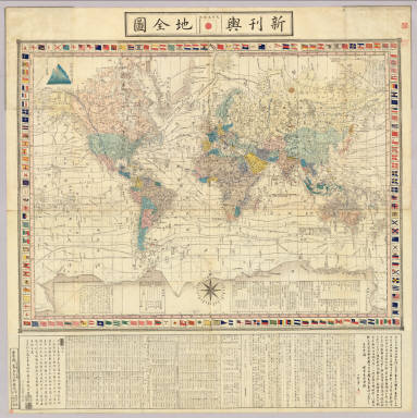
Detail View: Japanese Historical Maps: Kankyo shinkan yochi zenzu.
|
Author:
|
Sato, Seiyo
|
|
Date:
|
1862
|
|
Short Title:
|
Kankyo shinkan yochi zenzu.
|
|
Publisher:
|
Edo : Yorozuya Heishiro
|
|
Type:
|
Case Map
|
|
Obj Height cm:
|
85
|
|
Obj Width cm:
|
118
|
|
Scale 1:
|
None shown
|
|
Note:
|
Mounted cover title. Wood block print. In Japanese. Shows navigation routes of important explorers. Includes distance chart of sea routes from London and New York. Title on map: Shinkan yochi zenzu. Prefaces by Tobikawa Yoshikuni and Kimura Takeshi. Includes flags of foreign nations, texts on latitudes and longitudes, and legend. Engraved by Takeguchi Ryuzaburo and Kamimura Fukusaburo. Col., folded in cover 35 x 23 cm. East Asian Library call number: A12.
|
|
World Area:
|
World
|
|
Full Title:
|
Kankyo shinkan yochi zenzu : kan / Sato Seiyo. Bunkyu 2 [1862]
|
|
List No:
|
A12
|
|
Series No:
|
2
|
|
Publication Author:
|
Sato, Seiyo
|
|
Pub Date:
|
1862
|
|
Pub Title:
|
Kankyo shinkan yochi zenzu : kan / Sato Seiyo. Bunkyu 2 [1862]
|
|
Pub Note:
|
See note field above.
|
|
Pub List No:
|
A12
|
|
Pub Type:
|
Case Map
|
|
Pub Maps:
|
1
|
|
Pub Height cm:
|
35
|
|
Pub Width cm:
|
23
|
|
Image No:
|
A12
|
|
Institution:
|
Japanese Historical Maps
|