Detail View: Japanese Historical Maps: Dosen Nihon yochi zenzu.
|
Author:
|
Seika Shujin
|
|
Date:
|
1847
|
|
Short Title:
|
Dosen Nihon yochi zenzu.
|
|
Publisher:
|
[Japan] : Copyright by Seika Shujin
|
|
Type:
|
Pocket Map
|
|
Obj Height cm:
|
36
|
|
Obj Width cm:
|
33
|
|
Scale 1:
|
None shown
|
|
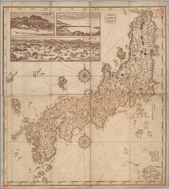
Note:
|
Copperplate print. In Japanese. Covers Matsumae to Tsushima, Okinoerabujima and Ogasawara. Includes 3 insets: Tanshu Amano Hashidate fukei -- Geishu Itsukushima fukei -- Oshu Matsushima fukei. Shows the distance of sea routes. Includes longitude and latitude and explanation of Kuroshio. Includes compass rose. Folded to 29 x 9 cm., in envelope 23 x 16 cm. East Asian Library call number Ca44.
|
|
Country:
|
Japan
|
|
Full Title:
|
Dosen Nihon yochi zenzu. [after 1847]
|
|
List No:
|
Ca44
|
|
Series No:
|
1
|
|
Publication Author:
|
Seika Shujin
|
|
Pub Date:
|
1847
|
|
Pub Title:
|
Dosen Nihon yochi zenzu. [after 1847]
|
|
Pub Note:
|
See note field above.
|
|
Pub List No:
|
Ca44
|
|
Pub Type:
|
Pocket Map
|
|
Pub Height cm:
|
36
|
|
Pub Width cm:
|
33
|
|
Image No:
|
jhm000032a
|